Find a great landaway experience, fast
Planning a fly-out is normally a mess of apps, maps, Google searches, phone calls and runway calculations. AirfieldFinder puts it all in one place.
Search by departure
Type your airfield and instantly see every destination in range
Filter to your aircraft
Set your cruise speed, runway needs, and flight time — results update live
See everything at a glance
Weather, restaurants, hotels, travel times, and runway details in one view
Everything you need to find the best place to fly
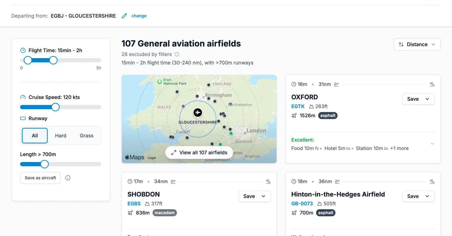
See every destination at a glance
Search from your departure airfield and instantly see every GA destination in range. Each card shows flight time, distance, runway details, and nearby amenities.
- Interactive map with all reachable airfields
- Flight time and distance for your cruise speed
- Runway length, surface type, and elevation
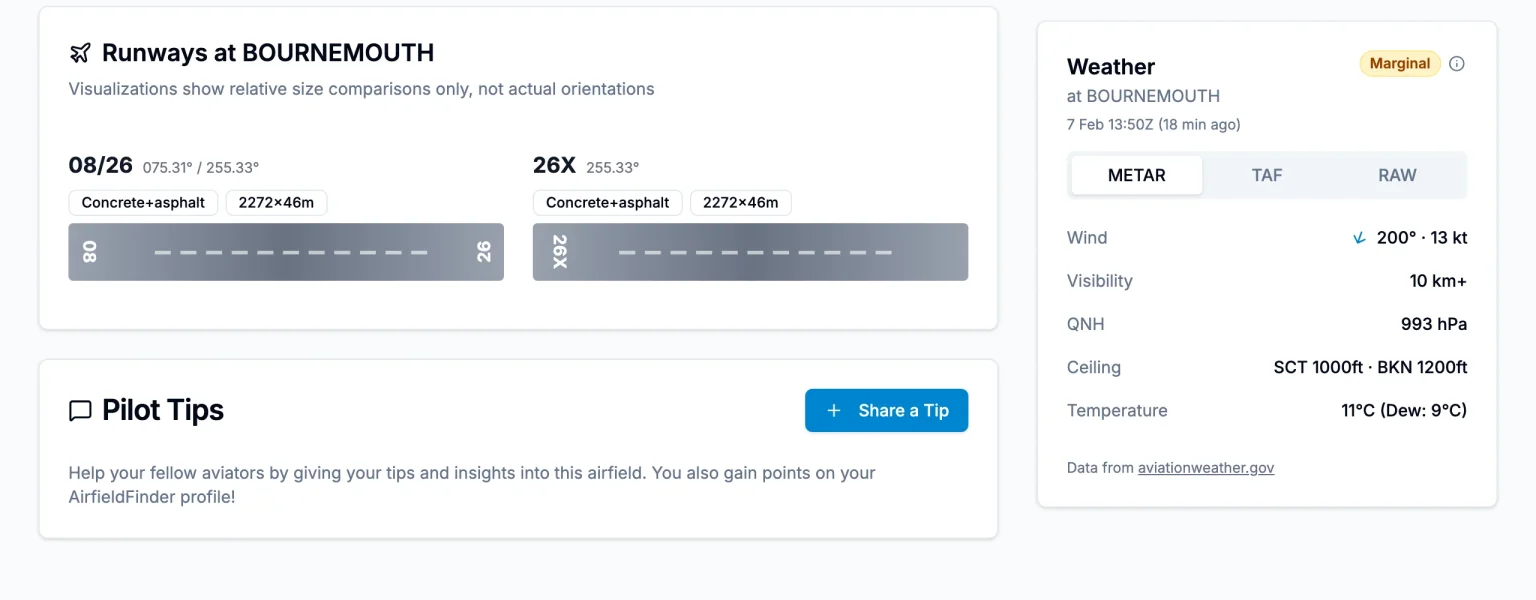
Live weather and runway detail
Real-time METAR and TAF data with flight condition indicators. Runway visualizations show surface type, dimensions, and orientation at a glance.
- VFR/MVFR/IFR condition badges
- Wind, visibility, QNH, ceiling, and temperature
- Proportional runway strips with surface gradients
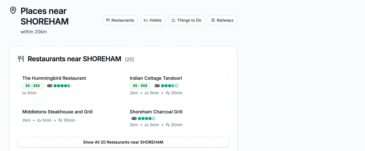
Find the best places to eat and stay
Restaurants, hotels, and things to do near every airfield. TripAdvisor ratings, cuisine categories, and door-to-door travel times so you know exactly what to expect.
- TripAdvisor ratings and price ranges
- Walking, driving, and transit ETAs
- Railway stations with live departure boards
Coming up at UK airfields
Upcoming events sourced from AeroAds.
Weston Park Model Airshow International (includes full-size aircraft)
Frequently Asked Questions
How many UK airfields are listed?
We currently list over 175 UK airfields, covering a comprehensive network of general aviation destinations across England, Scotland, Wales, and Northern Ireland. Our database is continuously growing as we add new airfields and update existing information.
What information is available for each airfield?
For each airfield, you can find nearby restaurants, hotels, and attractions with detailed transport times (walking, public transport, and car). We also provide TripAdvisor ratings, contact information, and practical details to help you discover fly-out destinations.
Is the service free to use?
Yes, AirfieldFinder is completely free to use for all general aviation pilots. We're continuously improving the platform based on user feedback. Simply search for your departure airfield to start exploring destinations.
What weather data is available?
Each airfield shows real-time METAR and TAF data, flight condition indicators (VFR, MVFR, IFR, LIFR), and live webcams where available. Wind components are calculated per runway so you can quickly assess crosswind. If an airfield doesn't have its own weather station, we fall back to the nearest available METAR.
Can I save my aircraft details?
Yes. You can save multiple aircraft profiles with your cruise speed, minimum runway length, and surface preference. Once saved, destinations are automatically filtered to match your aircraft performance, so you only see airfields you can actually use.
How can I contribute?
Share rich tips with photos by category (runway ops, food, transport, scenery) to help the community build the highest-quality airfield information. You can also report data corrections and request missing airfields. Quality contributions earn points towards your profile.
Ready to plan your next landaway?
Free to use. Save your aircraft, track airfields, and discover what's worth landing for.